


 Art & Design
 Auto & Vehicles
 Beauty
 Business
 Education
 Entertainment
 Finance
 Food & Drink
 Health & Fitness
 House & Home
 Libraries & Demo
 Maps & Navigation
 Medical
 Music & Audio
 Parenting
 Personalization
 Photography
 Productivity
 Shopping
 Social
 Sports
 Tools
Tools Travel & Local
 Video Players
 Weather
 Family


 ArcGIS QuickCapture
OS :
Version :1.15.125
Size :
Updated :Aug 26,2022
Developer :Esri
 Ask AI
You can ask
the AI some questions about the app
Here are three topics related to the ArcGIS Quick Capture app, turned into questions for you:
1. How do you use the photo and GIS data capture functionality in ArcGIS Quick Capture?
2. What are some best practices for collecting and uploading field data using ArcGIS Quick Capture?
3. How does ArcGIS Quick Capture integrate with other Esri apps and services for analysis and mapping?
 Ask AI
App
Downloads
<
>


App
Survey
-
Why do you uninstall an app?
-
Whether the app response speed affects the experience?
-
Do you think the aesthetics of the interface UI affects the experience?
-
Do you think the stability of the application affects the experience?
Description
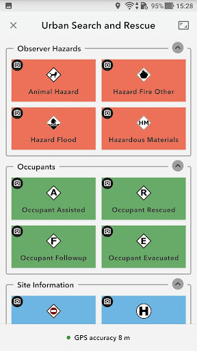
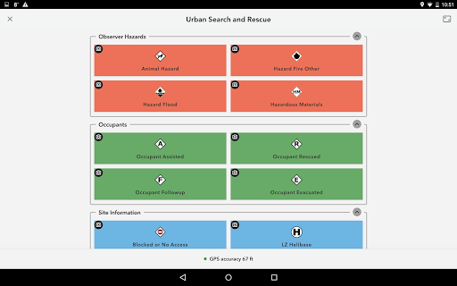
ArcGIS QuickCapture is the simplest way to capture field observations. Record GIS data with a single tap on your device. Automatically send locations, photos, and other attributes back to your office in real time. It’s integrated with ArcGIS, you can effectively visualize data you’ve never had access to before.
{{descriptionMoreText}}
Comments (0)
{{commentText.length}}/{{maxCommentText}}
{{commentError}}{{commentUserError}}
-
{{comment.commentUser.substring(0, 1)}}By {{comment.commentUser}}{{comment.commentDateString}}


Category Top
apps
- Google Play
- App Store
4
5
Lifestyle
 Daily Diary:Journal with Lock
 Life360: Find Family & Friends
 Pinterest
 T-Mobile Tuesdays
 Frecuencia
Photography
 Picsart AI Photo Editor, Video
 Amazon Photos
 Time Warp Scan - Face Scanner
 ToonApp: Cartoon Photo Editor
 Pixelup - AI Photo Enhancer


More Apps


