


 Art & Design
 Auto & Vehicles
 Beauty
 Business
 Education
 Entertainment
 Finance
 Food & Drink
 Health & Fitness
 House & Home
 Libraries & Demo
 Maps & Navigation
 Medical
 Music & Audio
 Parenting
 Personalization
 Photography
 Productivity
 Shopping
 Social
 Sports
 Tools
Tools Travel & Local
 Video Players
 Weather
 Family


 onX Hunt: GPS Hunting Maps
OS :

Version :22.28.0/22.41.0
Size :/291.68Mb
Updated :Sep 7,2022
Oct 28,2022
Oct 28,2022
Developer :onXmaps
 Ask AI
 Ask AI
Pros and Cons from users' feedback
Based on the user reviews of the app "Hunt" on Google Play Store, here are the conclusions:
**Pros:**
1. "Accurate maps and GPS tracking allow for seamless hunting experiences."
2. "User-friendly interface and simple navigation are highly appreciated."
3. "Real-time land ownership and hunting regulations information is invaluable."
**Cons:**
1. "Limited availability of maps, with some areas lacking detailed information."
2. "Subscription model can be overly expensive for occasional users."
3. "Occasional app crashes and freezes can be frustrating, especially in remote areas."
<
>

App
Survey
-
Do you think the aesthetics of the interface UI affects the experience?
-
Whether the app response speed affects the experience?
-
What exercise apps have you heard of or used?
-
The degree of memory and power consumption Does it affect the experience?
Description
★★★ Voted “one of the most innovative hunting products of the decade” by Field & Stream, the onX Hunt App is the must-have tool for the crews at MeatEater, Mossy Oak, and Realtree Outdoors.★★★
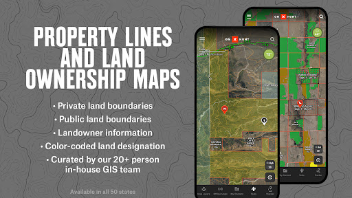
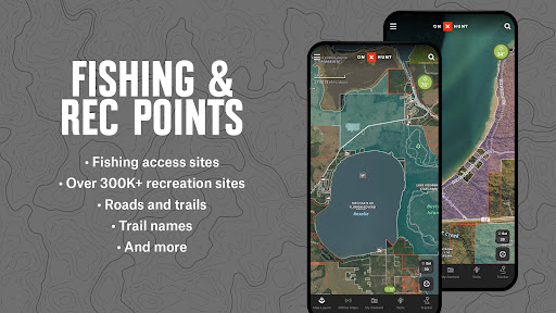
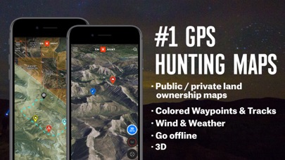
Know where you stand with the most trusted and accurate GPS satellite and topo maps. Use onX Hunt as a fully-functioning GPS navigation app on your phone. View private and public property land ownership data, landowner names, and property lines on your custom maps. Easily view hunting units, mountain roads and trails, US topographic maps, and more.
▶ FREE TRIAL:
While the onX Hunt App and many of its features are free, you’ll start a free Premium State Membership trial when you install the App. This allows you to try a full-featured Premium State Membership for seven days.
▶ FREE HUNTING APP FEATURES:
• NO ADS
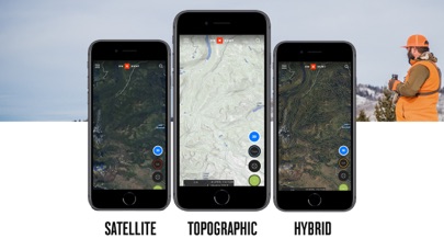
• Satellite Maps and 24K Topographical Maps with GPS Navigation
• 3D Maps on your phone and desktop computer
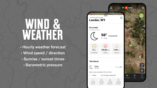
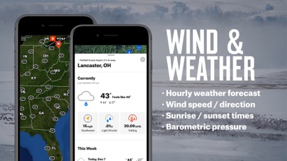
• Local weather conditions, forecasts, wind speeds, and wind direction sourced from Weather Underground and the National Oceanic Atmospheric Administration (NOAA)
• Aerial / Topographic Hybrid overlay to see contours with satellite imagery
• Hunting Zones, Areas, or Game Management Units (GMU) for general game species in all 50 states
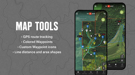
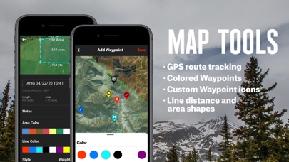
• Free Hunting GPS app with compass, Tracker, and Waypoints
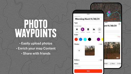
• Mark Waypoints with icons to navigate back to your vehicle, camp, or stand
• Easily measure distances between tree stands and blinds with the Line Tool
• Measure food plot acreage with the Shape Tool
• Track the distance, coordinates, duration, and speed of your hunt with our GPS Hunting Tracker
• Visualize wind direction at treestand locations
• Desktop version for scouting at home and syncing data to your mobile: www.onxmaps.com/web
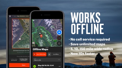
▶ OFFLINE GPS FUNCTIONALITY:
The onX Hunt App turns your phone into an outdoor handheld GPS navigator using the built-in GPS to display your location on the sat / topo map. Cellular coverage is NOT needed as tile-saving technology allows you to save basemaps and layers for offline navigation.
▶ DESKTOP MAPS: Memberships also include access to our online Web Hunting Map (www.onxmaps.com/web).
• Scout from the comfort of your home
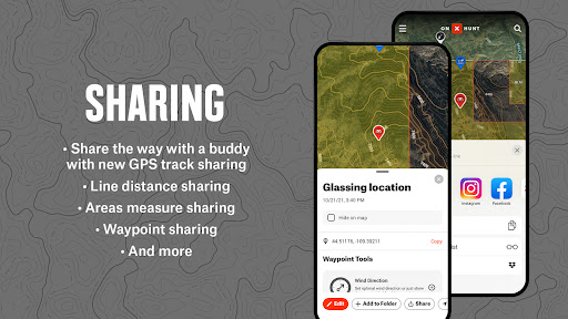
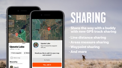
• Sync markups and tracks between devices
• Print unlimited free maps
▶ PREMIUM STATE MEMBERSHIP:
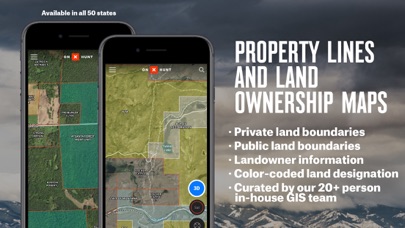
With a Premium State Membership, you gain access to our proprietary hunting GPS maps developed by our GIS team. A Premium State Membership costs $29.99 / year. Get all the great features of the free onX Hunt App PLUS the additional benefits of:
• Public land like Forest Service, Bureau of Land Management (BLM maps), Wildlife Management Areas, County and State land hunting maps, Timber Lands, and more
• 3D Maps on your phone and desktop
• Optimal Wind and Wind Calendar for stand locations and hunt planning
• Landowner names with property line maps and land boundaries finder in available counties (U.S. only)
• Search by landowner name or hunting property landowner boundaries to scout and look for new areas to Hunt
• Save private or public hunting land maps for offline use
• GMU or Hunting Units for multiple species (whitetail deer, mule deer, elk, turkey hunting and more)
• Possible Access Lands, Walk-In Areas, Block Management Areas, and private lands open to the public
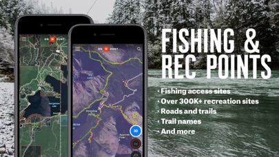
• The largest database of nationwide roads and trails ever built
* Private land ownership maps may not be available for all counties (U.S. only)
▶ ELITE NATIONWIDE MEMBERSHIP:
The best tool for the best hunters. With an Elite Membership, you get a complete, purpose-built solution for dedicated hunters and the game they pursue, including:
• Proprietary maps for all 50 states
• Exclusive tools and services from brands we trust to maximize your hunting experience
Easily scout, plan, and master your hunts for any species in any state for one membership price. Available for $99.99/year or $14.99/month.
▶ FEEDBACK:
Have a problem or want to request new features? Please contact us at [email protected].
Know where you stand with the most trusted and accurate GPS satellite and topo maps. Use onX Hunt as a fully-functioning GPS navigation app on your phone. View private and public property land ownership data, landowner names, and property lines on your custom maps. Easily view hunting units, mountain roads and trails, US topographic maps, and more.
▶ FREE TRIAL:
While the onX Hunt App and many of its features are free, you’ll start a free Premium State Membership trial when you install the App. This allows you to try a full-featured Premium State Membership for seven days.
▶ FREE HUNTING APP FEATURES:
• NO ADS
• Satellite Maps and 24K Topographical Maps with GPS Navigation
• 3D Maps on your phone and desktop computer
• Local weather conditions, forecasts, wind speeds, and wind direction sourced from Weather Underground and the National Oceanic Atmospheric Administration (NOAA)
• Aerial / Topographic Hybrid overlay to see contours with satellite imagery
• Hunting Zones, Areas, or Game Management Units (GMU) for general game species in all 50 states
• Free Hunting GPS app with compass, Tracker, and Waypoints
• Mark Waypoints with icons to navigate back to your vehicle, camp, or stand
• Easily measure distances between tree stands and blinds with the Line Tool
• Measure food plot acreage with the Shape Tool
• Track the distance, coordinates, duration, and speed of your hunt with our GPS Hunting Tracker
• Visualize wind direction at treestand locations
• Desktop version for scouting at home and syncing data to your mobile: www.onxmaps.com/web
▶ OFFLINE GPS FUNCTIONALITY:
The onX Hunt App turns your phone into an outdoor handheld GPS navigator using the built-in GPS to display your location on the sat / topo map. Cellular coverage is NOT needed as tile-saving technology allows you to save basemaps and layers for offline navigation.
▶ DESKTOP MAPS: Memberships also include access to our online Web Hunting Map (www.onxmaps.com/web).
• Scout from the comfort of your home
• Sync markups and tracks between devices
• Print unlimited free maps
▶ PREMIUM STATE MEMBERSHIP:
With a Premium State Membership, you gain access to our proprietary hunting GPS maps developed by our GIS team. A Premium State Membership costs $29.99 / year. Get all the great features of the free onX Hunt App PLUS the additional benefits of:
• Public land like Forest Service, Bureau of Land Management (BLM maps), Wildlife Management Areas, County and State land hunting maps, Timber Lands, and more
• 3D Maps on your phone and desktop
• Optimal Wind and Wind Calendar for stand locations and hunt planning
• Landowner names with property line maps and land boundaries finder in available counties (U.S. only)
• Search by landowner name or hunting property landowner boundaries to scout and look for new areas to Hunt
• Save private or public hunting land maps for offline use
• GMU or Hunting Units for multiple species (whitetail deer, mule deer, elk, turkey hunting and more)
• Possible Access Lands, Walk-In Areas, Block Management Areas, and private lands open to the public
• The largest database of nationwide roads and trails ever built
* Private land ownership maps may not be available for all counties (U.S. only)
▶ ELITE NATIONWIDE MEMBERSHIP:
The best tool for the best hunters. With an Elite Membership, you get a complete, purpose-built solution for dedicated hunters and the game they pursue, including:
• Proprietary maps for all 50 states
• Exclusive tools and services from brands we trust to maximize your hunting experience
Easily scout, plan, and master your hunts for any species in any state for one membership price. Available for $99.99/year or $14.99/month.
▶ FEEDBACK:
Have a problem or want to request new features? Please contact us at [email protected].
{{descriptionMoreText}}
Comments (0)
{{commentText.length}}/{{maxCommentText}}
{{commentError}}{{commentUserError}}
-
{{comment.commentUser.substring(0, 1)}}By {{comment.commentUser}}{{comment.commentDateString}}
Developer apps
- Google Play
- App Store


Category Top
apps
- Google Play
- App Store
4
5
Lifestyle
 Daily Diary:Journal with Lock
 Life360: Find Family & Friends
 Pinterest
 T-Mobile Tuesdays
 Frecuencia
Photography
 Picsart AI Photo Editor, Video
 Amazon Photos
 Time Warp Scan - Face Scanner
 ToonApp: Cartoon Photo Editor
 Pixelup - AI Photo Enhancer


More Apps


