


 Art & Design
 Auto & Vehicles
 Beauty
 Business
 Education
 Entertainment
 Finance
 Food & Drink
 Health & Fitness
 House & Home
 Libraries & Demo
 Lifestyle
 Maps & Navigation
 Medical
 Music & Audio
 Parenting
 Personalization
 Photography
 Productivity
 Shopping
 Social
 Sports
 Tools
Tools Travel & Local
 Video Players
 Weather
 Family


 MilGPS
OS :
Version :7.6.0
Size :30.17Mb
Updated :Nov 21,2022
Developer :Cascode Labs Pty Ltd
 Ask AI
You can ask
the AI some questions about the app
Here are three topics that users might discuss about the MIL GPS app on the internet, turned into questions:
1. What are your favorite features that the MIL GPS app provides for your outdoor adventures?
2. Have you experienced any issues with the app's accuracy or navigation in remote areas?
3. How do you find the MIL GPS app's user interface and navigation compared to other GPS apps you've used?
 Ask AI
Pros and Cons from users' feedback
I'd be happy to help you with that! After analyzing the user reviews on the Apple App Store, here are three pros and three cons of the MilGPS app:
Pros:
1. Accurate GPS tracking with reliable signal reception, even in remote areas.
2. User-friendly interface with easy navigation and customizable settings.
3. Offline maps and GPS tracking capabilities make it suitable for outdoor adventures.
Cons:
1. Limited map coverage and outdated maps in some areas, causing navigation issues.
2. Battery consumption is high, especially when using GPS tracking features extensively.
3. Some users experienced occasional crashes and freezing issues with the app.
Please note that these points are based on the user reviews and may not be exhaustive or entirely accurate. If you'd like me to clarify or expand on any of these points, feel free to
App
Downloads
<
>
App
Survey
-
Do you think the aesthetics of the interface UI affects the experience?
-
How do you feel about ads embedded in mobile applications?
-
Ease of use of the application Does it affect the experience?
-
Have you ever thought of deleting them?
Description
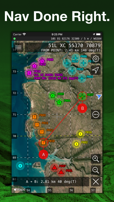
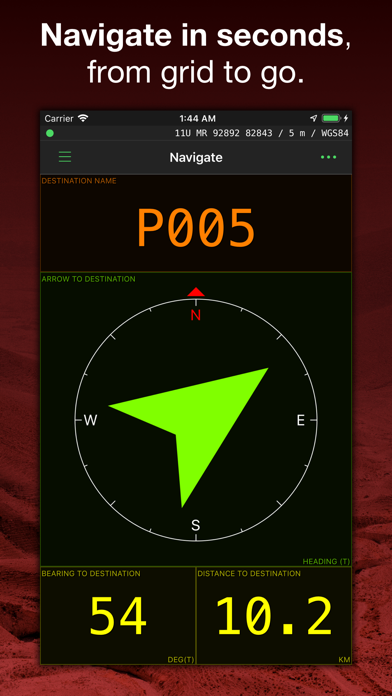
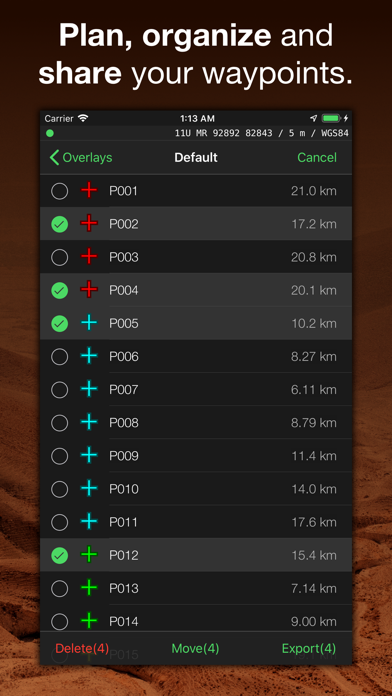
MilGPS is an MGRS/USNG focused premium navigation tool trusted by soldiers, search and rescue personnel and other professional navigators around the world. View your current location and navigate to a waypoint in seconds. Or plan and organize your navigation using the powerful and intuitive mapping and overlay capabilities.
FEATURES
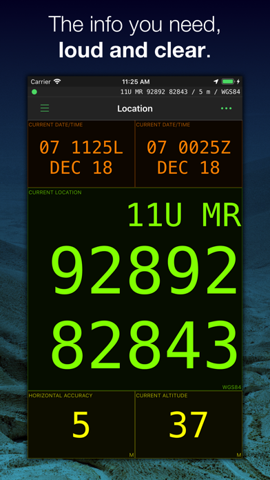
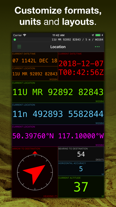
Display your current location in real time
- Cell phone signal not required but will make location fixes faster (maps require a data connection)
- Military Grid Reference System (MGRS) & United States National Grid (USNG) (4, 6 8 10 figure grid references supported)
- Universal Transverse Mercator (UTM)
- Latitude/Longitude (degrees, degrees and minutes, degrees minutes seconds supported)
- Ordnance Survey National Grid (grid and easting/northing in metres)
- Military date time groups for local/zulu time
- All info is displayed in large, clear text for easy viewing at all times
- Location and navigate screens are fully customisable - choose what info you want to see
- Wide variety of datums supported including WGS84, NAD27, OSGB36, AGD66, ED50
- Define up to 3 combinations of datum and location format for location display and waypoint entry
Create and navigate to waypoints
- Unlimited waypoints (upper limit dependent on device storage and memory)
- Enter waypoints from current location, map or using any of the above supported location formats.
- Live update of distance/bearing as you enter coordinates (sanity check your grids)
- Waypoints are fully editable, and can be sorted by distance or name
- "Quick goto" feature for quickly entering grids and navigating to them - accepts shortened MGRS grids.
- Receive an arrival indication as you approach your waypoint
- Import and export waypoints via the standard GPX file format (routes and tracks not currently supported)
Mapping
- View current location and waypoints on map, complete with custom smooth scrolling grid overlay (MGRS/USNG/OSNG/UTM)
- Choice of Apple or Google maps.
- Display user-supplied offline maps in raster MBTiles format.
- Use the crosshairs to position new waypoints and measure distances/bearings
- Choose from standard/satellite/hybrid/blank map type
- Grid overlay with labels for grid zones, 100km, 10km, 1km, 100m squares
- Map can be set to follow your current location and/or heading.
Other features
- Simple, intuitive interface.
- Convert between location formats easily using the add waypoint screen
- Supports degrees/mils for angle, with choice of true, magnetic or grid north reference.
- Supports feet/metres for altitude
- Supports imperial/metric/nautical units for distance
Why choose MilGPS over other apps?
- MilGPS is under active development and testing (since 2010)
- MilGPS is painstakingly crafted by an independent developer
- MilGPS emphasises accuracy, simplicity, ease of use and stability
Things that aren't in the app (yet):
- track recording
- route planning
- online mapping sources other than Apple and Google maps
App Store Privacy Information Note
Because you can choose to use Google maps in the app, we are required to disclose the data collected by Google in our App Store listing. If you do not use Google maps minimal data is collected. See our privacy policy for details.
NOTE: Mapping function requires a data connection. Using GPS will shorten battery life.
WARNING:
YOUR USE OF MILGPS IS AT YOUR OWN RISK
MilGPS is an aid to navigation only and is intended to be used in conjunction with other navigation methods and tools.
MilGPS must not be used where relying on MilGPS could result in death, injury or financial loss. This includes use on military operations, live-firing activities, aviation and surveying use.
MilGPS is not tested to military specifications and is not endorsed by the military of any nation. MilGPS is not a substitute for military issue equipment.
Your use of MilGPS is governed by the standard App Store Licensed Application End User License Agreement.
{{descriptionMoreText}}
Comments (0)
{{commentText.length}}/{{maxCommentText}}
{{commentError}}{{commentUserError}}
-
{{comment.commentUser.substring(0, 1)}}By {{comment.commentUser}}{{comment.commentDateString}}
Developer apps


Category Top
apps
- Google Play
- App Store


More Apps


