


 Art & Design
 Auto & Vehicles
 Beauty
 Business
 Education
 Entertainment
 Finance
 Food & Drink
 Health & Fitness
 House & Home
 Libraries & Demo
 Maps & Navigation
 Medical
 Music & Audio
 Parenting
 Personalization
 Photography
 Productivity
 Shopping
 Social
 Sports
 Tools
Tools Travel & Local
 Video Players
 Weather
 Family


 MapPad GPS Land Surveys
OS :
Version :7.5.0
Size :
Updated :Mar 9,2019
Developer :Mapit GIS LTD
 Ask AI
You can ask
the AI some questions about the app
Here are three topics that users might discuss about Mappad app online:
1. What features do you think are most useful in Mappad, such as map styles or route planning?
2. How has Mappad improved your daily commute or travel experiences with its navigation capabilities?
3. Are there any limitations or issues you've encountered while using Mappad, and how do you resolve them?
 Ask AI
Pros and Cons from users' feedback
Based on the user reviews, here are three cons and three pros, 15 words limited for each item:
**Cons:**
1. Difficulty with layout and navigation hinders seamless user experience.
2. Ads and pop-ups disrupt workflow and create frustrating interruptions.
3. Limited customization options restrict users' ability to personalize.
**Pros:**
1. Accessible offline capabilities allow for use anywhere, anytime.
2. Easy-to-use interface simplifies tasks and reduces learning curve.
3. Comprehensive features cater to diverse user needs and preferences.
App
Downloads
<
>


App
Survey
-
What are some of the most frequently used efficiency apps?
-
Whether the app response speed affects the experience?
-
What is your Mobile System?
-
Do you think the aesthetics of the interface UI affects the experience?
Description
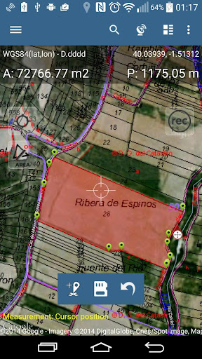
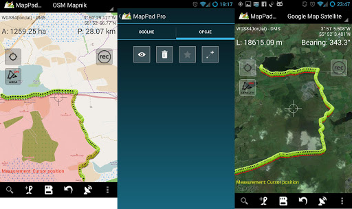
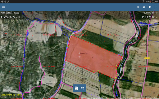
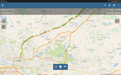
Use MapPad to calculate areas, perimeters and distances and save, export or share your measurements.
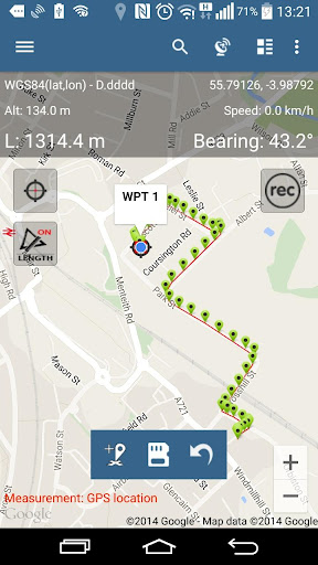
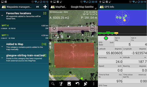
MapPad is providing multi-purpose mapping solution allowing location capture and determines distance and area for the shapes drawn on the map or captured using real-time GPS tracking.
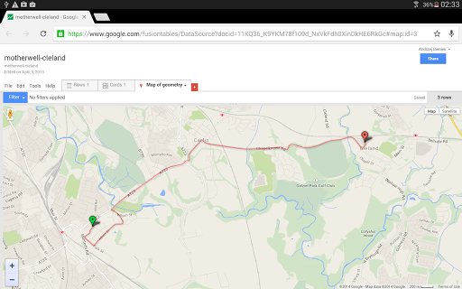
Calculate area of the field or a walk distance instantly using Google or Bing Map Satellite view. Save petrol and time and capture features with few clicks on the map.
With MapPad you can capture, manage and share your data easily.
MapPad is a very useful tool for anyone involved in forestry, agriculture, engineering and real estate management.
Please visit our website to find out how to prepare offline map and get more information about this product.
Selected features:
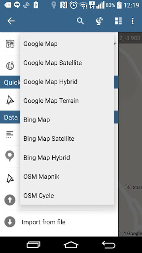
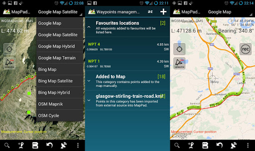
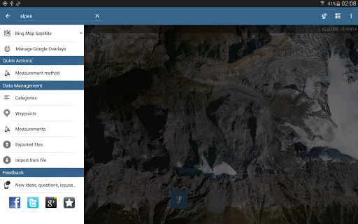
- Base maps: Google Maps, Open Street Map, Bing Maps
- Google Maps Overlays (Custom WMS or ArcGIS Server Tiled service), some layers like US Topographic map have been predefined.
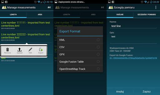
- Very accurate measurement of areas and distances.
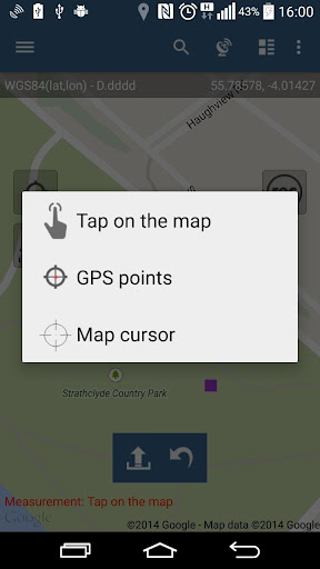
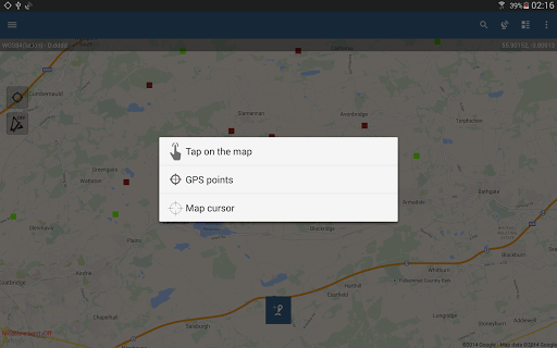
- 3 methods of measurement are supported (Tap on the map, GPS location, Map cursor location).
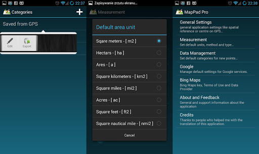
- Support for number of metric and imperial units.
- Support for several global and local coordinate systems, if you require support for any other spatial reference please get in touch.
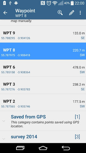
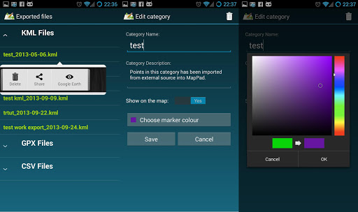
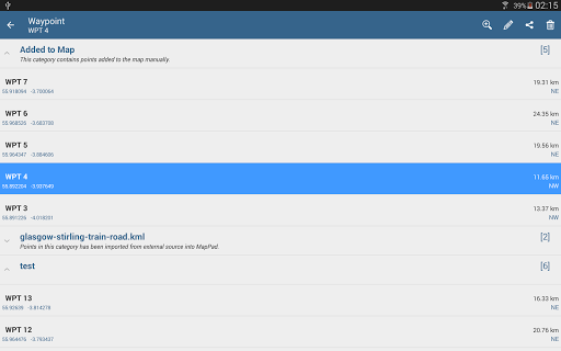
- Possibility to capture waypoints and group them in categories.
- Possibility to add or edit title and description for each recorded measurement and waypoint.
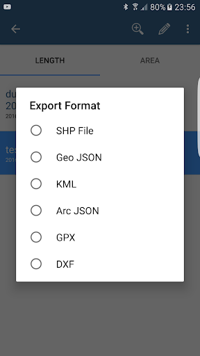
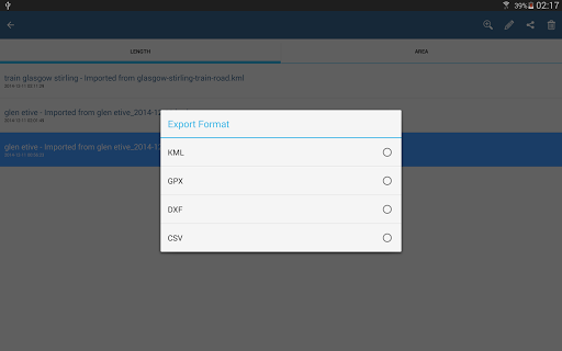
- Export single or multiple measurements or waypoints to SHP File, Geojson, ArcGIS Json, KML, GPX, CSV and DXF to SD Card or cloud services las well as direct export to Open Street Map.
- Share single waypoint location directly by SMS, E-mail or other ways.
- Elevation profile available for measurements done by GPS.
- Import of KML and GPX files to the application.
- GPS status and satellites status.
- Address, location search.
- Quick open exported KML files in Google Earth
- Ability to set default measurement units, waypoints' categories colours, track recording time and distance interval, transparency of Google Maps overlays and much more...
Our users are successfully using MapPad in number of projects and applications.
MapPad is providing multi-purpose mapping solution allowing location capture and determines distance and area for the shapes drawn on the map or captured using real-time GPS tracking.
Calculate area of the field or a walk distance instantly using Google or Bing Map Satellite view. Save petrol and time and capture features with few clicks on the map.
With MapPad you can capture, manage and share your data easily.
MapPad is a very useful tool for anyone involved in forestry, agriculture, engineering and real estate management.
Please visit our website to find out how to prepare offline map and get more information about this product.
Selected features:
- Base maps: Google Maps, Open Street Map, Bing Maps
- Google Maps Overlays (Custom WMS or ArcGIS Server Tiled service), some layers like US Topographic map have been predefined.
- Very accurate measurement of areas and distances.
- 3 methods of measurement are supported (Tap on the map, GPS location, Map cursor location).
- Support for number of metric and imperial units.
- Support for several global and local coordinate systems, if you require support for any other spatial reference please get in touch.
- Possibility to capture waypoints and group them in categories.
- Possibility to add or edit title and description for each recorded measurement and waypoint.
- Export single or multiple measurements or waypoints to SHP File, Geojson, ArcGIS Json, KML, GPX, CSV and DXF to SD Card or cloud services las well as direct export to Open Street Map.
- Share single waypoint location directly by SMS, E-mail or other ways.
- Elevation profile available for measurements done by GPS.
- Import of KML and GPX files to the application.
- GPS status and satellites status.
- Address, location search.
- Quick open exported KML files in Google Earth
- Ability to set default measurement units, waypoints' categories colours, track recording time and distance interval, transparency of Google Maps overlays and much more...
Our users are successfully using MapPad in number of projects and applications.
{{descriptionMoreText}}
Comments (2)
{{commentText.length}}/{{maxCommentText}}
{{commentError}}{{commentUserError}}
-
{{comment.commentUser.substring(0, 1)}}By {{comment.commentUser}}{{comment.commentDateString}}
-
EBy Eddie WaniJul 20,2022
-
SBy Suresh SureshJul 4,2022


Category Top
apps
- Google Play
- App Store
4
5
Lifestyle
 Daily Diary:Journal with Lock
 Life360: Find Family & Friends
 Pinterest
 T-Mobile Tuesdays
 Frecuencia
Photography
 Picsart AI Photo Editor, Video
 Amazon Photos
 Time Warp Scan - Face Scanner
 ToonApp: Cartoon Photo Editor
 Pixelup - AI Photo Enhancer


More Apps


